Ph.D. Program in Oceanography and Global Change at the Canary Islands, Spain
Submitted by ignacio on Wed, 05/25/2022 - 10:17

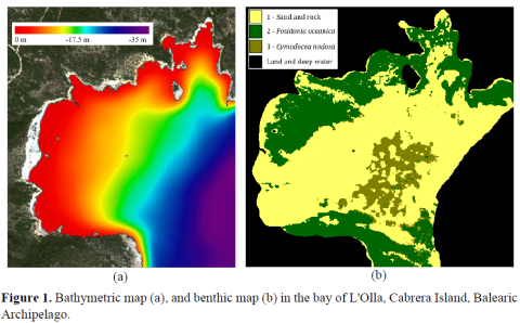
Remote spectral imaging of coastal areas can provide valuable information for their sustainable management and conservation of their biodiversity. For example, seagrass beds are very productive coastal ecosystems that serve as a refuge for other species, absorb atmospheric CO2, and protect the coastline from erosion. The Intergovernmental Oceanographic Commission (IOC) indicates that, at least, half of the world’s shallow coastal waters remain unmapped or poorly understood. Specifically, in Spain, protected areas cover 27.21% of its total surface and the coastline length is about 7,880 km. Preserved marine regions exceed the 8% but, nevertheless, only 25% of the littoral areas are being monitored in detail. These coastal areas are essential for the conservation of biodiversity and the provision of basic services for the society. Unfortunately, these areas are very sensitive to changes due to human activity, natural phenomena, introduction of non-native species, and climate change. The advantage of using remote sensing is the great spatial converger, periodicity, and low cost. However, advanced pre-processing techniques are necessary due to the high sensitivity of the signal to the effects of the atmospheric column, air and sea currents, water column, among others. The presented work aims to perform a comprehensive study and implementation of advanced pre-processing techniques using WorldView-2/3 imagery, in addition to advanced bathymetry and seafloor mapping using machine learning techniques.


Add new comment