Ph.D. Program in Oceanography and Global Change at the Canary Islands, Spain
Biodiversity supports a wide variety of ecological functions together with the services provided by ecosystems. Its conservation is related to global environmental changes such as the land use and land cover changes, climate change and sustainable developments. However, during the last century, humans caused alterations to ecosystems and thus, biodiversity is suffering a fast decline. The appearance of very high resolution sensors has offered a practical and cost-effective means for a good environmental management. The general objective of this research is the development of advanced processing techniques which, when they are applied to very high resolution remote sensing imagery, serve to obtain accurate information for the conservation of natural resources of vulnerable ecosystems. Different pre-processing steps have been applied in order to acquire high quality imagery. The thesis is focused in three ecosystems from Canary Islands, Teide National Park located in Tenerife Island, Maspalomas Natural Reserve in south Gran Canaria Island and two areas of north Fuerteventura, Corralejo Natural Park and Islote de Lobos. After an extensive analysis and evaluation, Weighted Wavelet ‘à trous’ through Fractal Dimension Maps and Fast Intensity Hue Saturation are used in the pansharpening process, then, a RPC model performs the orthorectification and finally, the atmospheric correction is carried out by the FLAASH algorithm. Once images were corrected and enhanced, the generation of products for the management of coastal and land resources were carried out. Pixel-based and object-based (OBIA) classification techniques were assessed and applied in order to obtain accurate information of the vulnerable ecosystems.

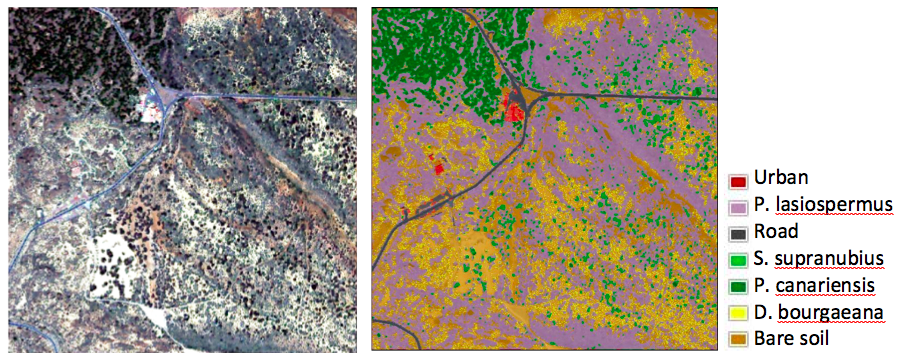
Figure 1. WAT⨂FRAC fused image with RGB color composition and thematic maps of WAT⨂FRAC fused image (left) using Support Vector Machine classifier (right).


